Category:Gila River Indian Community
Jump to navigation
Jump to search
English: The Gila River Indian Community (formerly known as the Pima Indian Reservation, est. 1859) — of the Maricopa and Pima peoples, in Maricopa and Pinal Counties, central Arizona.
federally recognized Native American tribe in the U.S. state of Arizona | |||||
| Upload media | |||||
| Instance of | |||||
|---|---|---|---|---|---|
| Location | Gila River Indian Reservation, Arizona | ||||
| official website | |||||
 | |||||
Subcategories
This category has the following 13 subcategories, out of 13 total.
G
H
J
- Matthew B. Juan (3 F)
M
S
- Sacaton Mountains (Arizona) (2 F)
- Stephen Roe Lewis (25 F)
- Sweet Water Village, Arizona (9 F)
V
- Vee Quiva Hotel & Casino (4 F)
Media in category "Gila River Indian Community"
The following 48 files are in this category, out of 48 total.
-
-
 1310R Gila River Indian Reservation Locator Map.svg 1,150 × 1,357; 3.93 MB
-

-
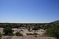
 2012, Life in the Desert - panoramio.jpg 4,000 × 3,000; 2.95 MB
-
 2014, South of Kuiwa, Santa Cruz Wash, Gila Valley, AZ - panoramio.jpg 6,000 × 4,000; 7.25 MB
-
 Africanized bee hive cross section.jpg 5,496 × 3,670; 4.25 MB
-
 Africanized honey bee hive.jpg 5,496 × 3,670; 6.32 MB
-

-
 AZMap-doton-Blackwater.png 260 × 300; 22 KB
-
 Bartlett Arizona Pimo Village.png 2,112 × 1,504; 5.58 MB
-
 Close-up of a cactus from the Pima Indian Reservation, Arizona, ca.1920 (CHS-3647).jpg 5,104 × 3,912; 1.28 MB
-
 Corral constructed by the Pima indians, Gila River Reservation, ca.1902 (CHS-775).jpg 5,412 × 3,874; 2.36 MB
-
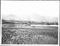
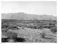 Farm fields on the Pima Indian Reservation, Pima, Arizona, ca.1900 (CHS-3617).jpg 5,023 × 3,865; 4.67 MB
-
 First Indian school in Arizona at the Pimo (i.e., Pima) Reservation.jpg 1,800 × 1,387; 1.32 MB
-
 Flag of the Gila River Indian Community.svg 512 × 307; 14 KB
-
 Giant saguaro cacti on the Pima Indian Reservation, Arizona, ca.1900 (CHS-3626).jpg 5,628 × 4,277; 1.94 MB
-
 GIla Coyote (5561706867).jpg 4,000 × 2,248; 7.45 MB
-
 Gila River Farms - panoramio.jpg 4,000 × 3,000; 4.78 MB
-

-

-

-

-
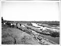
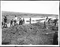 Group of Pima Indian farmers building a dam for irrigation, ca.1900 (CHS-3609).jpg 5,113 × 3,979; 3.94 MB
-
-

-
 Vanessa Paukeigope Jennings.jpg 250 × 318; 49 KB
-

-

-

-
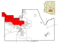
 Maricopa County Incorporated and Planning areas GRIC highlighted.svg 900 × 800; 127 KB
-

-

-

-

-

-

-

-

-

-

-

-
 Pinal County, AZ, USA - panoramio (49).jpg 4,000 × 3,000; 4.17 MB
-
 Sacaton Indian Reservation. Indian plowing his land. Salt River Project LCCN93502778.jpg 4,096 × 3,224; 1.84 MB
-
 Seed Farm Road, Gila River Indian Community, 2011 - panoramio.jpg 4,000 × 3,000; 4.4 MB
-
 The Pima Indians - pl 5a.png 1,862 × 1,317; 2.15 MB
-
 The Pima Indians - pl 5b.png 1,883 × 1,305; 1.91 MB
-
 Tom O'Halleran - 5.12.20.jpg 2,604 × 1,740; 521 KB
-


.jpg)
.jpg)
.jpg)
_Reservation.jpg)

.jpg)
.jpg)


.jpg)
.jpg)


.jpg)
,_Moadok_on_the_Horizon,_2012_-_panoramio.jpg)
.jpg)
,_ca.1902_(CHS-772).jpg)
,_ca.1902_(CHS-771).jpg)


.jpg)


.jpg)